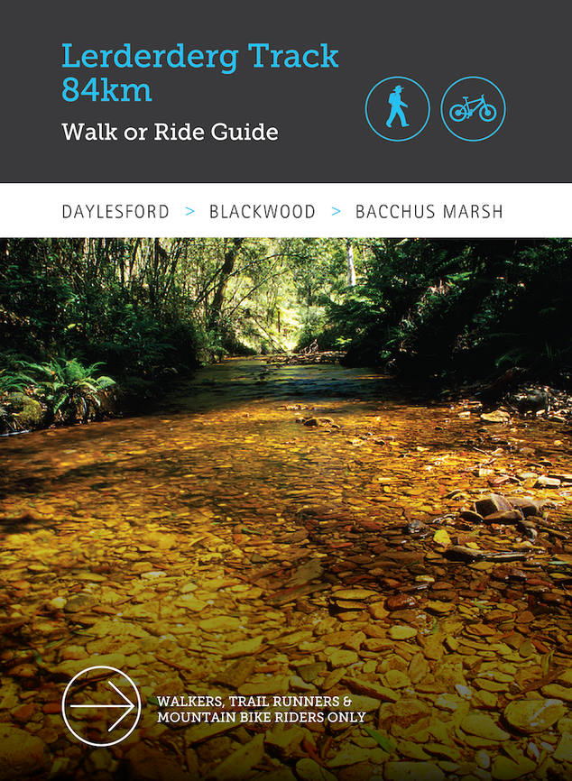
Lerderderg Track: Walk or Ride Guide, 84km from Daylesford to Bacchus March by Great Dividing Trail Association
Take a walk or bike ride along the wild and rugged Lerderderg River and its deep and remote gorge.
The 84km-long Lerderderg Track makes this possible. Traversing the top of the Great Dividing Range, the Lerderderg Track offers you access to a striking variety of landscapes – from tall messmate forest and blazing wattles; to an underworld of tree ferns framing your footpad next to a Heritage River; through to tortured, 300 metre-high cliff faces soaring above you at the gorge’s mouth.
While it will seem a world away, the track connects the vibrant central Victorian towns of Bacchus Marsh, Blackwood and Daylesford – all well within reach of Melbourne. The Lerderderg Track brings nature unlimited to your doorstep.
A proclaimed Heritage River, the Lerderderg and its geologically famous gorge is considered significant for its striking transition in vegetation and its diverse range of birds, animals and native fish. It is soon to become part of a new National Park.
The Lerderderg Track’s construction was initiated and managed in 2001 by volunteer bushwalking members of the Great Dividing Trail Association (GDTA). It forms the south-eastern leg of the Great Dividing Trail Network (GDTN), which also includes the 214km-long Goldfields Track stretching from Mt Buninyong to Bendigo. At close to 300km, the GDTN offers the longest shared use track for walkers and mountain bike riders in Victoria.
At its heart, the Lerderderg Track Walk or Ride Guide contains a series of detailed 1:17,500 ratio maps and track notes for walkers and mountain bike riders. But it consists of more than map spreads: the guidebook emulates the GDTA’s award-winning Goldfields Track Walk or Ride Guide by sandwiching the map spreads between vivid essays on the Lerderderg’s landscape and its cultural heritage. Its format allows you to choose to set off on short or long walks or bike rides. Along the way, you will encounter interpretive signage adding background context. And we have even developed seven, half day circuit walks to introduce you to features like spectacular water races, the log cabins of Blackwood or the historic side of Bacchus Marsh.
You will find the guidebook an essential companion for your venture into the wilds of the Lerderderg. With book in hand, you can select where to go, read all about it, then simply follow the blue-topped posts.
Specifications:
Publisher: Em Press Publishing
Year: 2025
Format: Paperback
Pages: 138pp
ISBN: 9781955777882
$34.99
2 in stock
Description
Take a walk or bike ride along the wild and rugged Lerderderg River and its deep and remote gorge.
The 84km-long Lerderderg Track makes this possible. Traversing the top of the Great Dividing Range, the Lerderderg Track offers you access to a striking variety of landscapes – from tall messmate forest and blazing wattles; to an underworld of tree ferns framing your footpad next to a Heritage River; through to tortured, 300 metre-high cliff faces soaring above you at the gorge’s mouth.
While it will seem a world away, the track connects the vibrant central Victorian towns of Bacchus Marsh, Blackwood and Daylesford – all well within reach of Melbourne. The Lerderderg Track brings nature unlimited to your doorstep.
A proclaimed Heritage River, the Lerderderg and its geologically famous gorge is considered significant for its striking transition in vegetation and its diverse range of birds, animals and native fish. It is soon to become part of a new National Park.
The Lerderderg Track’s construction was initiated and managed in 2001 by volunteer bushwalking members of the Great Dividing Trail Association (GDTA). It forms the south-eastern leg of the Great Dividing Trail Network (GDTN), which also includes the 214km-long Goldfields Track stretching from Mt Buninyong to Bendigo. At close to 300km, the GDTN offers the longest shared use track for walkers and mountain bike riders in Victoria.
At its heart, the Lerderderg Track Walk or Ride Guide contains a series of detailed 1:17,500 ratio maps and track notes for walkers and mountain bike riders. But it consists of more than map spreads: the guidebook emulates the GDTA’s award-winning Goldfields Track Walk or Ride Guide by sandwiching the map spreads between vivid essays on the Lerderderg’s landscape and its cultural heritage. Its format allows you to choose to set off on short or long walks or bike rides. Along the way, you will encounter interpretive signage adding background context. And we have even developed seven, half day circuit walks to introduce you to features like spectacular water races, the log cabins of Blackwood or the historic side of Bacchus Marsh.
You will find the guidebook an essential companion for your venture into the wilds of the Lerderderg. With book in hand, you can select where to go, read all about it, then simply follow the blue-topped posts.
Specifications:
Publisher: Em Press Publishing
Year: 2025
Format: Paperback
Pages: 138pp
ISBN: 9781955777882


Book Reviews Reviews
There are no reviews yet.